Monday, November 20, 2006

Emu parade

By Rod Smith

Our first attempt to climb The Emu ended at a red backpack at the top of the cliff.

After frustrating hours spent getting lost and scrub-bashing along the indistinct trail to Kedumba Walls, the presence of another party on the 10-pitch adventure route spelled the end of our quest.

Annoyed, scratched and sleep-deprived we bowed to good judgement and decided that the four of us would end up climbing in the dark if we pushed on.

On that occasion we turned around and scrub-bashed back, in 30-degree temperatures, to the car and thence to the pub at Leura.

Savage with disappointment, we downed enough beers to unanimously vow never to go near The Emu again.

Yet here it was, just one month later and we – me, John Shaw, Rick Fielding and Gus Davidson – were once again standing at the top of this infamous adventure climb in the Blue Mountains near Sydney.

Our earlier trip had not been a waste. From the intelligence gained we reached the top of The Emu in just 45 minutes, compared with the two hours it had taken us the first time around.

There are two ways of accessing the climb. After reconnoitring the walkdown last time, we elected for the three-abseil option using our two sets of 60m double ropes to speed up the transitions.

After 90 minutes of abseiling and walking we reached the base of the climb. An old water bottle and various cairns mark the start.

There’s been a lot of stuff written about The Emu. Most significantly the uncomplimentary article in Rock magazine which makes the route sound like a death-trip.

There are also two route descriptions that vary significantly: Roger Bourne’s classy topo on the Boycetown website http://www.geocities.com/mountboyce/MainFrameSet.htm, with its detailed pitch descriptions and drawings, gives the route’s crux at 17.

The description in our own publication Rockclimbs in the Upper Blue Mountains calls the climb 15, with a 17 variant pitch.

From our point of view Roger’s information was on the money although Rockclimbs in the Upper Blue Mountains provides vital route-finding information.

The time was a bit after 11am as I led up the pleasant grade 14 slab corner/crack that is the first pitch. Gus quickly followed which allowed John and Rick to begin.

The second pitch was Gus’s and it required a short walk through a narrow chimney to the base of the cliff. This was followed by bridging up the tightish squeeze, using cams and nuts in the right-hand wall. After a slabby section, the pitch exits up an easy, unprotected, juggy orange wall near a cave.

Pitch 3, mine, was a bit scrappy with most of the protection being in the form of slings around a few small trees, followed by an unprotected haul onto a juggy slab behind a grasstree (blackboy).

The top out was on a small triangular stance with a dwarf apple gum, which Roger describes correctly as a “weak tree”.

I volunteered to also lead pitch 4 which is a slab corner that goes at either 14 or 16. For me this pitch felt like 16. The gear was also suspect: Gus was belayed into the weak tree and a 0 Friend while I tottered upwards, protected for the first half of the slab by a 00 Friend, a No. 2 RP and a No.1 Rock. After that there is no gear for the last 3m. A fall would have been nasty.

I believe pitch 4 is the same pitch on which first ascentionist Greg Mortimer (who put up the route with Lucas Trihey and John Ewbank in 1993) is pictured in Rock magazine.

The run-out to the top of the slab was followed by some nice climbing up a well-protected flake section before the top-out onto the treed ledge. Here we stopped for a 15-minute lunch break.

Gus scored pitch 5 which begins with a short climb up some blocks and then a traverse around a corner to an exposed position, looking onto massive walls of choss. We broke this pitch into two, with Gus leading both. The second part went up a shattered arête with good cams, into a sandy ledge which Gus gingerly traversed to the next tree belay. Roger notes that this part contains a “sickening void”.

I found pitch 6 quite enjoyable. It flows easily up a small orange wall then into a well-protected corner before exiting onto a gravelly ledge.

At grade 12, it felt easier than pitch 5 which is grade 11. After topping out on pitch 6 I wandered to the left and tied into some trees and welcome shade.

Pitch 7 starts directly above the tree belay. A steep bouldery start, it’s tough for a grade 14 which is why the small, dead tree at its base shows signs of being used as a de facto step ladder. Gus led this pitch which includes a tricky grovel through a backpack-grabbing tree onto a slab and up to a small ledge with a tree belay.

Pitch 8, the crux, was short and sharp. After setting off up the ferny left-wards groove I quickly found a nice cam on the left wall followed by a bomber hex in the corner. Some tricky stemming – which felt closer to grade 17 than 15 – was followed by another cam and a nut and a leftwards exit onto a ledge.

Wanting more crux I wandered leftwards along the ledge only to discover that that was the end of the pitch.

Gus followed up and quickly took off above my comfy two-cam belay to begin the grade 12 pitch 9. A well-protected chimney, it abruptly exits onto a scrubby she-oak (casuarina) ledge.

Rather than belay on the slippery slope scrub Gus bushwalked upwards, occasionally slinging trees, until he was close to the start of the final pitch.

Pitch 10 is a grade 5 or 8, depending on whose instructions you read. Really it was just an easy scramble upwards for 10m before the welcome sight of our backpacks.

Gus and I topped out at 5.55pm. John and Rick surfaced a bit over an hour later.

In the twilight we packed up. Half way out it was dark. With head torches on and John’s GME GPS providing vital route-finding corrections we found the car and from there we fled to the pub.

Over beers we vowed never to go near The Emu again…

Thursday, October 19, 2006

Operation: Wolgan

By Rod Smith

Voices in the dark: Many garbled voices from over the UHF radio, and a single one coming from somewhere up on Lower Baldy.

The radio voices were the excited, massed gabblings of those back at the campsite where day two of the SRC Wolgan Valley sheep roast weekend was in full, boozy swing.

The lone voice belonged to Mike Patterson who with his second had decided to spend the night on the half-way ledge of Lower Baldy.

With four beers onboard myself, I had joined Hamish Kerr and Roger Austin in a search for the missing duo after they failed to return from a day on the hill.

Standing in the ruined tennis court of the Wolgan Valley mine manager’s house, we yelled Mike’s name. Minutes later a calm voice answered back. Mike told us that he was on The Chain and due to a certain shortness of abseil rope and lack of head torches would be spending the night on the half-way ledge.

A quick check of the Wolgan Valley guidebook revealed that the claimed 50-odd metre height of The Chain was probably more like 80m if they were on the ledge.

Aware that Mike, in the spirit of the ’70s-tinged feel of the sheep roast weekend, was wearing nothing but a pair of jeans, a t-shirt and a massive handlebar moustache, it was decided that a rescue would be effected, regardless of his shouted intentions.

The plan fell together. Hamish announced that he would walk up to the half-way ledge and locate the missing. Roger and I decided to go to the base of The Chain, near Secret Swinger, retrieve packs, head torches and the all important shoes and meet up with Hamish on the walkdown descent of Solo Gully.

With every walkie-talkie in the valley tuned to channel 1, the whole operation had the surreal feel of a reality TV show. But the reality was that it was more a retrieval than a rescue.

At the base of Secret Swinger Roger and I were joined by Hugh Ward and Nigel Donnelly. With both ready to climb The Chain in the dark it was only a radio call over Hamish’s walkie-talkie that scuttled their night-time ascent: Hamish had located the missing pair.

By 11pm everyone was back in camp. Most headed for their sleeping bags while others reached for another beer.

Beer seemed to be a key ingredient of the first SRC Wolgan sheep roast in several years.

For roast organisers Luke Merritt and Hugh Ward it had fortified them from 8am on the Saturday morning when they began to dig the fire pit and assemble the spit.

It kept fortifying them throughout the day as they watched the two dressed lambs slowly roast while the rest of the camp went off and climbed rocks.

They were still quaffing strongly when it came to carving up the roast at 9pm and on into 1am when your correspondent called it quits and hit the sack.

Among those attending was SRC Life Member and veteran of countless roasts Russell Taylor who is also the custodian of the spit.

Amid dozens of families who’d fled to the Wolgan for the October long weekend, SRC members claimed a chunk of the Little Capertee Campsite that is unremarkable but for the fact that it inexplicably contains a rock with a red Nazi swastika painted on it.

The roast itself was superb: beautifully cooked meat served with tabouli and flatbread and consumed with joy by the light of dozens of head torches.

For most, Monday heralded a return to the city. For myself and Jim Dickins it meant another three days of climbing in faultless spring weather.

After a nine-week absence from climbing due to an injured hand, six days of climbing in the Wolgan seemed to me the perfect way to make up for some lost time.

Highlights included the classic The Pulpit on Lower Baldy, the very fine Decline and Fall on Lower Coke Ovens, the hot, sunny May Day Mayday at Petrie’s and the imposing Khe Sanh at the Lower Coal Mines.

With the SRC gang gone and the town hordes significantly diminished the largely absent wildlife returned to the campsite.

On our last night Jim and I sat with our dwindling beers, amazed at the sight of six wombats grazing almost side by side like sheep while up in the sky a huge ring appeared around the almost-full moon.

Friday, August 18, 2006

Off-routed

By Rod Smith

It’s at Narrow Neck, it’s a three-star classic, old-school, must-do.


It sounds like a sales pitch.


In this case I was selling pitches, three of ’em, the ones that make up Fuddy Duddy. The buyer, as is usually the case, was Gus. And, as is usually the case, he said yes.


Trad-training for our big end-of-year trip we decided that it would be a valuable way to spend a few hours on a Saturday and give us an opportunity to break out the double ropes.


With John Shaw and Rick Fielding we completed the familiar two-hour drive from coastal Sydney to the deep canyons of the Blue Mountains.


We abseiled down Herbaceous Gully and waved John and Rick goodbye when they stopped at their goal Cave Climb.


By the time that Gus and I got to the base of our route, carried out our ablutions, racked up, drank water and decided where the first pitch started it was near 10am on one of those glorious blue and sunny days that are considered winter by Sydneysiders.


Words to the effect of "smaller block down and right of the monster” and “wall to ledge below top of block” in Bede Harrington’s indispensable Rockies’ compendium “Rockclimbs in the Upper Blue Mountains” - seemed to concur with what we looking at, as did the initials FD at the bottom of the intended pitch. Confident that we were on track, I headed up the wall, past a bolt then lots of easy climbing, another bolt and then a comfy ledge with two carrots form a double-bolt belay.


It did not occur to me even when Gus reached the belay that we might be on the wrong pitch. The penny only dropped after I headed off around the corner to be confronted by what I considered to be a gear-free death traverse to the obvious corner and crack second pitch that gives the climb its 15 grade.


Reversing the moves I told Gus what I suspected had happened. Together, with new eyes, we noticed how the bolts of the belay were actually sticking out an unhealthy distance and how the huge detached flake below us and a metre distant from the rest of the cliff had the familiar whitened patina of classic, oft-climbed sandstone routes.


We concluded that the description in the book was probably the original 1960s route. My mind vaguely recalled reading in Mike Law’s guide how the first pitch of Fuddy Duddy had “fallen off” in a rock slide that was now generally considered to be stable…


We had somehow wandered up another route that appeared to finish at the two dodgy bolts or else traverse out wildly to the right below a roof and around a corner. According to Bede’s book it’s likely that it was Riverstone One, the route description to which notes “route details in dispute”.


The only thing to do was to sacrifice some gear to the rock gods, rap off the long bolts and gently pendulum onto the top of the big fin of rock that is Fuddy Duddy’s true first pitch. A long quickdraw and two biners poorer and we were at the base of the second pitch.


At it turned out this pitch alone was worth the hefty price of admission.


A soaring corner crack, it begins with a bolt-protected move before seguing into an offwidth that requires a borrowed number 5 Camalot for protection. After that it’s a glorious feast of stemming and laybacking or jamming to the end of the pitch.


The final pitch is also a gem of a different style. Notionally a 13 it begins with an old- school grade 18 bouldery start that allows you to clip a trusty piton. I actually opted for the right-hand start which seemed marginally easier than the left-hand heave that Gus opted for. I also placed a cam rather than solely trust the trusty piton


After that is the chimney. Fat folks need not apply.


I found plenty of gear in the left hand wall, closer to the outside of the chimney. In the bit where the gear was sparse I was so firmly squeezed, what with two layers of warm gear and my rack, that I was never going to fall out. A nice number 3 Friend allowed me to get out of the chimney and stem up on its outside edge to enjoy airy positions and the jet-stream that was funneling upwards and providing a vertical tailwind.


After a couple of false starts weighed down by the daypack Gus was directly below me. We then packhauled the daypack on one of the half ropes to allow Gus full enjoyment of the squeeze chimney.


Back at the car I calculated that a mere 95m of climbing had taken us almost 5 hours. As we pondered this and munched our sandwiches in the winter sun, we decided that we really didn’t care how long it had taken.


In the words of Fuddy Duddy fan club member Will Monks “If you don't like this climb f*** off to Centennial Glen or Nowra and don't come back!”.

Thursday, July 20, 2006

Frenchman's Cap: The Walk

Article from The Sun-Herald's Explore magazine.

By Rod Smith

LIKE a signpost, the sun-bleached King Billy pine stump marked the top of Barron Pass and the end of our struggle up the steep, rainforested slopes.

For the past two hours life had been reduced to a slow trudge up to the mountain pass which marks the psychological, if not lineal, half-way point of the 50km return trip to Frenchmans Cap in South-West Tasmania.

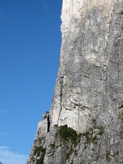
With the end of the climb up to the pass and our weighty packs off our backs, our surroundings came into sharp focus on this hot, Tasmanian summer day. Out of a near cloudless western sky loomed our goal, the massive quartzite half-dome of Frenchmans Cap.

Like a single tooth biting the blue sky, the 1446m peak’s sudden re-emergence – after a short, tantalising glimpse at the start of the walk the previous day – stripped away our fatigue. It was a view that held us for a good 40 minutes at Barron Pass, much longer than we had so far lingered anywhere else on the walk in.

It was a view that also meant just two hours more walking to our second night’s accommodation, the sturdy little 16-berth hut beside Lake Tahune. From Tahune Hut we planned to make our bid for the summit of the Cap and enjoy the expansive views into the surrounding World Heritage wilderness, weather willing.

Our trip had begun at 10am the previous day when our six-man party had travelled for four hours from Launceston in a hired 12-seater bus.

The Frenchmans Cap National Park trackhead begins on the Lyell Highway, about 55km from the West Coast mining hub of Queenstown. On the way there we passed through Derwent Bridge and the terminus of the renowned Cradle Mountain-Lake St Clair National Park Overland track. But where the Overland Track is so popular that a one-way walking rule and limits on walker numbers have been introduced to regulate the booted hordes, Frenchmans Cap National Park remains comparatively low-key.

But as the Tasmanian Parks and Wildlife Service warns in its literature Frenchmans “is considerably more arduous than many other Tasmanian walks, including the Overland Track”.

The Frenchmans Cap walk traditionally begins, as did ours, with a group photograph beneath the Frenchmans Cap sign. After registering our walk details in the track logbook we made the pleasant 10-minute walk to the banks of the Franklin River.

It’s the same Franklin that in 1983 international outcry and a High Court ruling saved from becoming part of a new hydro-electricity impoundment.

Two years after that victory, in 1985, a teenager and his mates hauled themselves and their packs across the Franklin in a flying fox as they embarked on their first ever Frenchmans Cap walk. Twenty-one years later and I’m no longer a teenager, I’m back with a different set of mates but disappointingly there’s no flying fox. Nowadays a springy one-at-a-time suspension bridge gets you across the river in seconds.

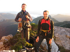
After crossing the river our party sorted itself into two groups: father and son Simon and Peter Kearney would travel at their own pace, probably camping at one of the tent sites. My group of four was determined to reach the spacious 20-berth hut at Lake Vera, 16km away.

The decision to break our group into two parties was both expedient and safe: Each group carried tents and an EPIRB (or Emergency Position Indicating Radio Beacon) as well a pair of UHF walkie-talkies tuned to the same channel. In the event of injury or sudden and severe weather we could make camp, communicate with one another or, as a last resort, set off an EPIRB and wait for the rescue helicopter to come.

For Simon the trip was something of a personal odyssey: his maternal great-grandfather was none other than J. E. Philp the hardy bushman who, with two companions, was contracted to cut the original Frenchmans Cap track in 1910 as a prospector’s track. Philp’s exploratory efforts are remembered in landmarks like Philps Peak, Philps Lead and Philps Creek. Lake Vera is named after Philp’s wife, Simon’s great-grandmother.

The Parks and Wildlife Service warn prospective Frenchmans Cap walkers that the track in general has a surface that “may be rough and muddy over extended sections, especially across the Loddon Plains”. This is an understatement. The Loddon Plains are always rough and muddy, hence their nickname the Sodden Loddons.

For Frenchmans Cap walkers this seemingly endless buttongrass bog is the first day’s major obstacle. Admittedly the first hour away from the river is a long uphill drag around Mount Mullens, but it is not as mentally demanding or physically taxing as the Sodding Loddons.

Unlike many popular Tasmanian walking tracks, only a tiny part of the Loddons has been boarded. This has resulted in an ever-spreading network of unofficial tracks as successive walkers attempt to avoid the worst of the mud.

Make no mistake, whatever strategy you use you’re going to get very muddy. After carefully and cleanly negotiating the early sections you’ll invariably step onto a solid-looking piece of track and suddenly it will swallow you up to your knees. After spells of wet weather that could mean sinking up to your waist.

It took our four-man party three hours to cross the plains using a combination of hopping from tussock to tussock, edging carefully around the bogs and charging through and hoping the mud wasn’t as deep as it looked. We baked beneath a sun that on that first day reached 31 degrees C in Queenstown. We drank litres of water from the many small streams that flow along the way, even in the height of summer. Then suddenly the track veered west and began climbing a gentle hill. We had cleared the Loddons.

Encased in an armour of mud up to our knees, we took a short break and snacked on that most ubiquitous of bushwalker delicacies the dried fruit and nuts mix called scroggin. Keeping up energy stores by staying well fed and thus fuelled is as important as being well hydrated.

As we sat dozens of voracious march flies descended upon us. Slow, dopey and resembling a blowfly, march flies are perhaps the least enjoyable aspect of summer walking in Tasmania. They disappear when you’re move but attack relentlessly when you are stopped. The only bonus is that they’re quite easy to swat and so provided us with ongoing opportunities for vengeance, when we could be bothered.

Aside from the flies, the thought of clean clothes and the night’s hot food brought us to our feet and we pushed on towards Lake Vera Hut. With the Loddons behind us we reasoned that the day’s obstacles had disappeared. Not so. As would happen a number of times on this challenging walk, one obstacle was replaced by another.

The steep drag up through the temperate rainforest of Philps Lead sapped our final reserves of strength. Conversation ceased and all of us could feel the twitch of muscles starting to cramp, no doubt due to the salt loss from our voluminous sweating. Even as we began the descent into Lake Vera there was little to be said.

After almost eight hours of walking we just wanted to get there.

It’s amazing what a cup of pea and ham soup, a wash down in a mountain stream, dry clothes and the prospect of a soft, inflatable Thermarest mattress will do for the psyche of the exhausted bushwalker. Within two hours of taking up residence in the bright and cheery circa 1979 Lake Vera Hut our enthusiasm had returned.

The next morning, after a sleep-in, the four of us decided to push on to Lake Tahune.

So far the weather had been fine, but there were no guarantees it would stay that way.

The Frenchmans Cap area is one where the Parks and Wildlife Service notes that “rain normally falls on 15 to 20 days each month during summer and more often in other seasons”.

It would be fair to say that the beauty of the ancient moss-covered myrtle beeches, sassafras and other rainforest species that cover the sheltered slopes beneath Barron Pass were apparent to me on the walk out of Frenchmans Cap, but not on that second morning as we grunted up the inclines.

During that two-hour ascent my mind alternated between a succession of banal pop songs, that had somehow become lodged in my mind and were now being played on high rotation in my head, and focusing on the track markers. After spotting a marker I’d promise myself a rest when I reached that point, then I’d will myself on to the next and insist that all along I had meant the next marker was the rest spot.

Using this combination of self-deluding head games and my internal FM station from hell, I managed to make the top of Barron Pass just in front of the other three, if only to get my mind back on the scenery. The pass is an exposed saddle bookended by quartzite: the slender pinnacle of Nicole’s Needle and the squat bulk of Sharland’s Peak. When I called down and told the others that I’d made the top the news was met with a mixture of joy and responses that promised murder if it wasn’t so.

We spent the time at Barron Pass lunching on flatbread, cheese and salami and simply staring at the vast bulk of the snow-white rock of Frenchmans Cap.

After lunch we left Barron Pass and headed dramatically downwards before the track climbed once more before gaining a ridgeline. From there we descended into the sheltered and surreally green Artichoke Valley, with its soft beds of sphagnum moss and the plentiful pineapple grass from which it derives its name.

From there it was up some steep metal stairs to the top of another ridge around some hillsides, and a sharp descent until suddenly Tahune Hut appeared out of the trees. It had been almost 5 hours since we’d left Lake Vera.

Lake Tahune itself is a place of immense beauty that is best described by E. T. Emmett in his indispensable 1953 and sadly out-of-print book Tasmania by Road and Track: “The immediate surroundings of this sepia pool are pines, and right out of it for a sheer couple of thousand feet rise the white cliffs of Frenchmans Cap’’.

Tahune Hut was built in 1971 to replace the original that was destroyed by fire. It is small and cosy with room for 16 at a pinch but better suited to about 12. We shared the hut with six others: five people from Sydney’s central coast and a well travelled Irishman who walks mostly in Scotland.


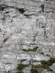
We awoke on the third day to weather that was more spring than summer – windy, cool and threatening rain. Within hours, however, summer had returned. With the prospect of 360-degree vistas on the top of the mountain we packed our daypacks and headed up the serpentine walker’s track that takes you to the top of the mountain.


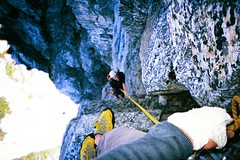
The track to the top has changed in recent years and now avoids the north col which is undergoing intensive rehabilitation work. Instead the 450m ascent takes a zig-zagging path up durable rock shelves and a couple of low-angled rock slabs. It’s a steep climb but after two days of heavy packs it felt like a stroll to the shops.

Less than an hour later we were standing on top of the Cap on a near perfect day. Out west we could see the jagged shores of Macquarie Harbour and the shining sands of deserted beaches. To the north we picked out Tasmania’s highest peak Mount Ossa and the other significant high points in the Cradle Mt-Lake St Clair National Park. Closer to Frenchmans we simply marvelled at how the ancient peaks protruded like bones from the verdant skin of the heavily forested earth.

When surveyor James Sprent became the first person to officially climb the Cap in 1853, Tasmania was still known as Van Diemen’s Land and the transportation of convicts had only stopped the previous year. Amazingly 153 years later the vistas that Sprent enjoyed are little changed from the views that we spent two hours absorbing.

Sprent would have been surprised by the westerly view, which now includes the vast man-made hydro-electric impoundment called Lake Burbury. But his surveyor’s soul would probably have rejoiced over the engineering feat that is the Lyell Highway.

For us urban-dwellers the view was extraordinary simply because in every direction that we looked humanity appeared to be absent. Lake Burbury could have been a natural lake and the Lyell Highway – visible here and there – was devoid of cars. Everywhere else was simply mountains and unbroken tracts of forest.

After two hours of visual feasting only the banality of hunger and the promise of stodgy, freeze-dried Mexican chicken, bulked up with Deb instant potato, drew us back down the mountainside. That night, as we ate our carbohydrate-rich concoction, I felt the first pangs of what in the next few days would become regret. Tomorrow when we began the walk back our adventure would be drawing to its end.

The next morning, after accepting that the trip was more than half done, it seemed more pragmatic to focus on the positive side of returning to the inhabited earth. So if climbing the Cap was the single motivator for the three-days before, drinking beer and eating a huge counter meal at the Derwent Bridge Hotel was the dual motivator for our return to civilisation.

Our return journey to the Lyell Highway covered the same ground but it asked less of us: our diminishing food made our packs lighter and there were more down hills than ups. The two-day walk out took us a total of eight hours with plenty of time to stop and enjoy what we’d missed coming in. In comparison it had taken us 12 hours to cover the same distance during the walk in.

On a day that we emerged from the bush the temperature again reached 30 degrees C. After several hours spent washing clothes, swimming and relaxing on the rocky shores of the Franklin River the call of the unwild became stronger than ever.

By late afternoon the six of us were back together, this time sitting in the cool dimness of the Derwent Bridge Hotel. Still wearing the same clothes we’d worn on and off for the past five days, we drank beer like it was the tannin coloured Lake Tahune water, which it resembled. We spoke tiredly and sporadically of a trip now fast becoming a memory.

And whether it was simply tiredness or the softness of the hotel’s couches I’m not sure, but at times I felt myself momentarily absent, the beer glass in my hand tipping dangerously. It was as if I was back there, among the white sun-warmed rocks, on top of a mountain peak shaped liked a tooth, drinking in the views.

Wednesday, February 15, 2006

Fear and loathing in South-West Tasmania

beginning
By Rod Smith

Beneath the massive half-dome of Frenchman’s Cap my courage shattered and fell like a shard of quartzite rock kicked from the summit.

As the 7am summer sun warmed the white rock of the distinctive 1446m peak in South-West Tasmania, all that I could think of were reasons not to climb.

“I’m not doing it, I’m coming down,’’ I announced to my climbing partner Gus Davidson and Simon Kearney, who’d come along for the walk.

The first mistake was skipping coffee. The second was believing that the cold, shaded, crumbling, overhanging gully could possibly be the start of Tierry Le Fronde. The third was heading up it.
morning

When I finally decided to bail, it felt like a betrayal, but at that moment I didn’t care.

“Some times you have to obey the screaming little man inside, this is one of those times,’’ I sagely told Gus and Simon.

Then I sat down and, head in hands, began a mental battle: Screaming Little Man versus rational me.

In the meantime Simon and Gus wandered off, taking photographs of each other, and the magnificent surroundings.

Or so I’m told.

Oblivious to all, I sat for what turned out to be an hour trying to get back some mental equilibrium. Then I announced it was time that the three of us went and did something with the day. Perhaps a bushwalk, or a lazy day sitting in the sun at Lake Tahune, reading a book.

Over on The Sydney Route, I spied a tiny speck that the camera zoom showed was Nigel Donnelly belaying Mike Patterson who was negotiating the fifth pitch of Jack Pettigrew and Bryden Allen’s 1965 classic route.
start

Nigel, Mike, Gus and I had been training for weeks to climb the 380m, 13-pitch, grade 17 The Sydney Route.

When the allotted day came for Gus and me to head up the line the morning was wet and windy and we all went back to sleep, ignoring the intended 5am start. Later, in improving weather, we reconnoitred the route from its base only to find that its shady, upper pitches were wet.

Gus and I discussed the possibility of climbing and after gazing at it for a couple of hours we concluded that as a team, even if we had started on time and the rock had been dry, we probably weren’t up to the rigours of the route.

On that same day, as the four of us sat in the sun on top of Frenchman’s Cap taking in the views on a near perfect summer’s day, we firmed up our plans for the next day. Gus and I would seek a more achievable but no less worthy prize: Tierry Le Fronde a grade 16 climb of six pitches. Nigel and Mike would have The Sydney Route all to themselves.

But my plans to bag a classic were as if dust the next morning as I walked back up the steep descent gully after bailing off the climb. I felt angry as I studied the startling arête that Tierry Le Fronde follows for most of its 150m length. I felt unworthy to be carrying the rack of Friends and Hexes that dragged around my neck.

Then I thought of the sheer efforts we’d made to be here. How our six-man party had carried 30kg-plus packs in 30-degree plus weather. How we’d grunted up hill and down dale to gain 900m vertical height, spent hours negotiating the energy-sapping Loddon Plains bogs before finally collapsing at Lake Tahune after slogging 25km in two days. Not to mention the logistics of getting everyone and their gear to South-West Tasmania.

It’s true that we were all fatigued from the massive efforts of the walk in – by trip’s end and despite eating massively I had lost almost 5kg. But if the walk was a difficult grind then the climbing was meant to be the pleasurable reward. Now here I was about to throw it all in. It seemed so selfish, impotent and just downright rude.

I stopped, uncoiled the rope and said to Gus “I think I’ll just head up here for a look”.

Thirty metres off the deck, climbing in the sun on an easy angled-slab I placed my first piece of protection and everything felt right. “I think I’ll keep going,” I told Gus.

We were on the way.

For the next six hours the pair of us revelled in the challenge of this classic route. Sustained and exposed, it follows the shadows to the left-hand side of the main arête up the Tahune face.

After the 45m long slabby non-pitch to a big ledge, the first pitch led up a pleasant sun-illuminated wall before gaining a small stance and ducking into the shadows.

I inadvertently strung together the second and third pitches. That 56m mega-pitch provided some of the most enjoyable climbing that I have ever done. It was here that the crux appeared about the same time as a rusted and bent-over piton, possibly placed by the first ascentionists – Chris Dewhirst and Phillip Stranger in 1968.

Despite repeated attempts to clip the piton I was forced to climb on, the distance between me and my last piece of protection growing longer.

Interestingly I remember feeling no fear: instead I felt the thrill of being high up in an exposed position, stemming on small holds and engrossed in the task at hand. It was a task complicated by the dwindling amount of gear on my rack.

After a couple of attempts with wires I settled on a tiny cam. From there I ran it out to the top of the third pitch – an airy perch on an exposed pinnacle with huge views of the surrounding wilderness.
upwards
Tied into a number 10 hex that someone else had left behind, I brought Gus up. We both felt good and took a couple of photographs with my compact film camera to mark the occasion.

The next pitch began with a delicate unprotected traverse then up a not-so-delicate face to a large ledge. Then it was around the ledge and up to the base of a corner. Here Gus and I stood and gazed up at the impressive overhangs that provided the last obstacle to the top.

With the end in sight I led off and was soon among a series of overhanging quartzite fins. Some careful stemming around shifting blocks combined with some full-blooded hauling on more secure holds brought me to the final overhang. With one handjammed beside a protruding flake and searching for a cam, I looked down as my last bit of gear lifted out and slid down the rope. Six metres above my last piece of protection, I felt the protruding flake shift beneath the pressure of my jam.

Now beginning to feel vulnerable I quickly selected a cam and plugged it in beside the shifting flake before setting off and up and onto the belay seat. Gus quickly followed and we both stood on a small perch looking up at the exit, a sloping offwidth but easy chimney with which we quickly dispensed.

Sitting in the alpine bushes in the sun and finally eating our lunch, I felt happy and euphoric. As we took in the views I privately compared the now with the then of six hours previously when I’d begun the climb.

In the morning I had wanted to give the game away, now I wanted to climb forever.

Much later, Gus and I were relaxing back at Tahune Hut when the two-way radio went scratchy with static before seguing into Mike Patterson saying “Rod are you there? We’ve just finished?”. Ten hours and 13 pitches later Mike and Nigel were 400 vertical metres above us, descending down to the hut with Simon.

That night, over several shots of whisky, we traded tales about our day out on white rock under blue skies.

Wednesday, January 18, 2006

Please excuse our French

By Rod Smith

After months of traditional climbing training we are now on the cusp of the long-awaited trip to Frenchman’s Cap.
(Picture, right: The South-East Face. The Sydney Route is the second route from the left).

On Friday Gus, Nigel, Mike and I will fly to Tasmania to prepare for our Sunday walk into the Cap.

Simon and his dad will complete our party, although they’ll be doing the walk only.

The four climbers have their sights set on Bryden Allen’s 1965 classic route A Toire La Gloire or, as it is more popularly known, The Sydney Route.

Three of the climbing party are members of the Sydney Rock Climbing Club, so it’s appropriate that we’re revisiting a route put up by one of our most accomplished members and one of Australian climbing’s most unsung heroes.

I can’t help but admit to feeling a little anxious, what with the route being 380m long with about five sustained pitches in the grade 16 or 17 area.

But as I offered to Mike today, the only thing we can do is take it one pitch at a time.

Any way, we’ll be back in Sydney on January 29 by which time I hope to have many tales to tell.